A walk across a dried-up reservoir (Photo: Nagara Gopal / The Hindu)
Telangana has three million irrigation pump sets. Half of them have already run dry. That is not an opposition leader’s charge; it is a figure Chief Minister Revanth Reddy gave on October 23. And one name is being blamed for it all — El Niño.
The name was born on the other side of the world. Centuries ago, fishermen on the coast of Peru noticed something strange. Every few years, right around Christmas, the sea turned warm and their nets came back empty. They named the oddity after the Christ child: in Spanish, El Niño means “the little boy”.
Today the same name echoes across Telangana, from TV studios to roadside tea stalls. Yet ask what it actually means, and most people have no answer. We fear what we do not understand. Once we understand it, fear turns into caution.
What exactly is El Niño?
Put simply, El Niño is a fever in the Pacific Ocean. When we run a fever, the whole body goes weak. When the Pacific runs a fever, the whole world’s weather goes haywire.
To see how it works, picture a large water tank with a table fan blowing across it from one end. The warm surface water is pushed to the far end and piles up there. At the fan’s end, cold water rises from below.
That is exactly what normally happens in the Pacific. The fan here is the trade winds. They blow from South America towards Indonesia and Australia, pushing warm water west. Where the water is warm, there is more evaporation, more cloud and more rain. Off Peru, the water stays cold and teems with fish.
Now imagine the fan slows down. The piled-up warm water slowly slides back east, towards Peru. The central and eastern Pacific heat up. The rain clouds drift east with the warm water. Wind patterns shift, and rainfall across the world is thrown off balance. That is El Niño.

Pull one end of a large saree, and the folds shift at the other end. In the same way, a change in the Pacific’s winds stirs the weather thousands of kilometres away.
Nobody brought it, and nobody can stop it. It is a natural cycle that has turned for thousands of years. It usually returns every two to seven years and lasts nine to twelve months.
So why should a bore well in Warangal dry up because the sea warmed off Peru? Because our southwest monsoon is part of the same wind system. When the Pacific’s clouds change course, the moisture that should reach us from the Arabian Sea and the Bay of Bengal weakens. That is why El Niño years are more likely to bring us less rain.
Decoding the jargon
La Niña, super El Niño, Modoki, IOD — the terms heard on TV all belong to one family. None is as complicated as it sounds.
La Niña — El Niño’s opposite. The fan blows harder and the Pacific cools. For us it usually means good rain, sometimes floods.
Super El Niño — The term used when the sea warms more than 2°C above normal. It is not an official category, just a nickname for a very strong El Niño. 1982–83, 1997–98 and 2015–16 were of this kind. So is 2026. Because this one is now breaking records, weather expert Leon Simons has called it a “super-duper El Niño”. That is a nickname too, not a scientific class.
Modoki El Niño — Japanese for “similar, but different”. The heat gathers in the middle of the Pacific rather than at its eastern end. Its blow to India can sometimes be harder. The 2009 drought was of this type.
IOD (Indian Ocean Dipole) — A game played in our own ocean. When the western Indian Ocean, near Africa, is warmer than the eastern part, it is called a “positive IOD”. It brings us rain and softens El Niño’s blow.
Niño 3.4 — A box that scientists have drawn in the middle of the Pacific; think of it as the spot where the ocean’s thermometer sits. When the water there runs more than 0.5°C above normal, it counts as El Niño.
Remember just two things. In the Pacific, El Niño is our enemy; in our own Indian Ocean, a positive IOD is our friend. Whoever wins their battle decides our monsoon.
What history tells us
El Niño is nothing new for us. For about 150 years, its shadow has hung over India’s major droughts. But it has never played out the same way twice.

| Year | Strength | What happened in India |
|---|---|---|
| 2026 | On course to be the strongest on record | Monsoon rainfall of 759 mm, 12.6% below normal. The first deficient year since 2015. |
| 2023 | Strong | The country scraped through at the edge of “normal” (94%). But August was the driest on record. |
| 2015–16 | Super | Back-to-back droughts in 2014 and 2015, with a 12.7% deficit in 2015. That December, floods swamped Chennai. |
| 2009 | Moderate (Modoki) | The worst drought in decades. Rainfall was 23% short (IMD’s Mausam journal). |
| 2002 | Moderate | Rainfall 20.9% short. July saw a 51.5% shortfall nationwide — the driest July on record. For the first time in 133 years, not a single monsoon depression formed all season. |
| 1997–98 | Super | A surprise: normal rain for us, thanks to a positive IOD. Indonesia’s forests burned; Peru flooded. |
| 1987 | Strong | Severe nationwide drought. Rainfall 14.3% short. |
| 1982–83 | Super | Drought, with rainfall 11.4% short. At the time it was called “the El Niño of the century”. |
| 1972 | Strong | Rainfall 22.3% short. Severe drought and food shortages across the country, Maharashtra included. |
| 1876–78 | Very strong | The Great Famine in South India. Millions starved to death, including in the Madras Presidency and Hyderabad State. |
Deficits are June–September all-India figures; the 2009 figure is from a Mausam study. Year-by-year data is in IMD’s El Niño and monsoon rainfall table.
The lesson is simple. In about 60 per cent of El Niño years since 1951, India received below-normal rain. Six times out of ten the blow landed; four times, other factors saved us. El Niño is not a guarantee of drought. It is a warning.
One more thing. So many died in 1876 not only because the rain failed. The rulers of the day kept exporting grain through the famine and tied relief to hard labour. Rain is in nature’s hands. Whether a drought kills is in the hands of those who govern.
Why the alarm this time?
Because 2026 is no ordinary El Niño. It is on course to surpass every El Niño recorded since 1950.
According to the October 8 update from NOAA, the US weather agency, parts of the eastern Pacific are more than 4°C warmer than normal. NOAA puts the chance that this event breaks the record of every El Niño since 1950 during October–December at 83 per cent, and expects it to stay strong until March 2027.
One point needs care here. That 83 per cent is a forecast of how strong El Niño will be in the Pacific. It does not mean our districts face an 83 per cent chance of drought. What happens here also depends on our seas, our clouds and our reservoirs.
The numbers climbed further in October. Climate scientist Zeke Hausfather noted that sea temperatures in the Niño 3.4 region had reached 3.4°C above normal — higher than any El Niño on record. The World Meteorological Organization (WMO) expects a record 3.7°C during October–December.
Sea-level images released by NASA satellites on October 23 look almost identical to those of the 1997 super El Niño. The WMO expects this El Niño to peak in December and last until February.

And this time, no friend is in sight. IMD’s October outlook says the IOD is neutral and likely to stay that way through the northeast monsoon. The same outlook expects below-normal rain for the country in October. There is no positive IOD to shield us as there was in 1997.
What do scientists actually say?
TV debates trade in fear. Research papers deal in numbers. And the numbers say six things clearly.
One: El Niño feeds itself. Once the trade winds weaken a little, warm water moves east. That narrows the temperature difference between the eastern and western Pacific. A narrower difference weakens the winds further, and the warm water moves further east. Scientists call this loop, in which ocean and air keep pushing each other, the “Bjerknes feedback”. That is why an El Niño, once started, keeps strengthening for months.
Two: its arrival shows up months in advance. Huge pulses of warm water that travel east beneath the ocean surface are called Kelvin waves. Satellites caught the first one near Micronesia as early as January 2026. By April they had reached the eastern Pacific and were warming the sea. NASA scientist Josh Willis calls Kelvin waves the heartbeat of El Niño.
Three: where El Niño heats up matters to us. In 2006, a team led by K. Krishna Kumar studied 132 years of rainfall records and reported a key finding in the journal Science: every severe drought in India came in an El Niño year, but not every El Niño brought drought. When heat builds up in the central Pacific (the Modoki type), India is more likely to face drought than when the heat sits at the eastern end. This time it is mostly at the eastern end, as in 1997. Yet we still ran short in 2026. Whether an El Niño this strong overrides even the difference in type is a question scientists have yet to answer.
Four: forecasts have limits. Every year, El Niño forecasts stumble between March and May, a problem known as the “spring predictability barrier”. Once an El Niño has set in, forecasts of its strength are reliable. But NOAA itself says its effects are not certain. As NASA scientist Severine Fournier puts it, every El Niño is different.
Five: climate change amplifies the impact. Scientists do not yet agree on whether a warming planet will bring El Niños more often or make them stronger. But the sixth assessment of the UN’s Intergovernmental Panel on Climate Change (IPCC) is clear on one point: by the second half of this century, the rainfall swings driven by El Niño and La Niña are very likely to grow. Tomorrow’s El Niños could bring harsher droughts and floods.
Six: El Niño also turns up the heat. Air moves in a loop. When it rises over the central and eastern Pacific during El Niño, it has to come down somewhere to close the loop — and it comes down on our side. Sinking air warms, dries out and stops clouds from forming. With no cloud cover, the sun beats straight down on the land. What is more, El Niño’s heat often hits hardest in the summer after its peak. 2016 and 2024 were such years. This time, that summer is 2027.
The science in short: we can see El Niño coming months ahead and measure its strength. But how hard it hits our village is not decided by the Pacific alone.
What lies ahead for Telangana
Figures in this section are as of October 24, 2026.
The state has been hit hard. Of the 740.6 mm of rain Telangana should have received this monsoon, only 615.5 mm fell — a shortfall of about 17 per cent. With the October rains also staying away, the gap is still widening.
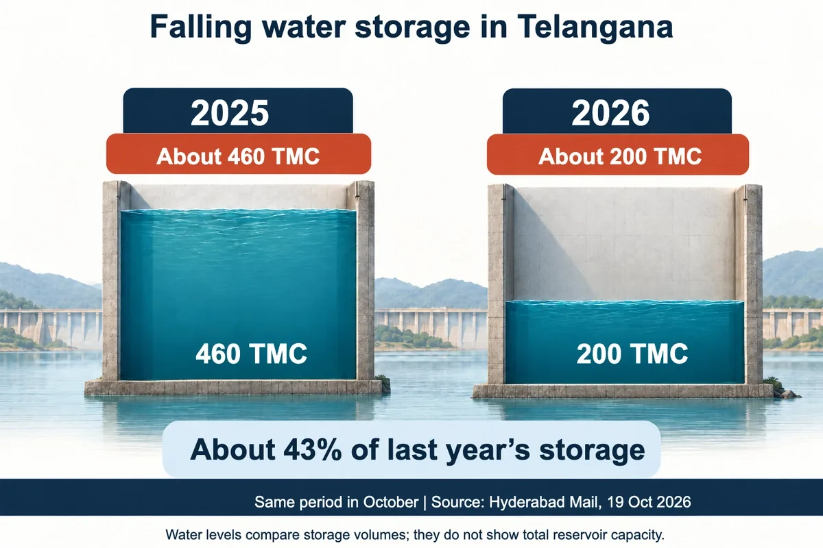
The reservoir figures are more alarming. A year ago, the state’s reservoirs held about 460 TMC (thousand million cubic feet) of water; today they hold just 200 TMC. More than half is gone. Oddly, on June 1 the Krishna basin reservoirs held more than their ten-year average. Summer did not hurt us; the monsoon did.
At a review meeting at Praja Bhavan on October 23, the Chief Minister was blunter still. The drinking-water crisis could last until July next year. Irrigation water may not be available for the yasangi (rabi) season, so he urged farmers not to sow paddy.
Hyderabad will not escape either. The city’s water board has already warned that the Manjeera and Singur reservoirs are running low. Tanker demand, which normally peaks between March and July, began months early this year. A Climate Trends study says summer-like heat could set in as early as February.
What lies ahead is not a single summer, but a long test of eight to ten months.
El Niño: shield or sword?
In politics today, El Niño is used in two ways. In the ruling party’s hands it is a shield. In the opposition’s, a sword.
The Chief Minister himself says the opposition accuses his government of “bringing the drought”. No government can be blamed for the rain failing. Nobody in Hyderabad heated the Pacific. Pinning nature’s work on a rival is playing with people’s fears. The opposition’s real charge, however, is that the drought stems from the failure to use the Kaleshwaram project. The government counters by pointing to the sinking of the Medigadda barrage.
Equally, the government cannot escape by booking every hardship to El Niño’s account. This El Niño did not arrive out of the blue. IMD warned of below-normal rain on April 13. NOAA officially declared El Niño in June. The government itself says it has been sounding the alarm for six months. So what did it do in those six months? How many tankers for which village, how much water from which reservoir, where the fodder for cattle will come from, and if not paddy, what farmers should grow instead — these questions remain unanswered.
El Niño is an act of nature. But how much damage it does is decided by people. What we need is not frightening speeches, but a plan backed by numbers — from the ruling party and the opposition alike.
Myths and facts
“There will be no rain at all in an El Niño year.” Wrong. Heavy rain and floods can still come. A study in IMD’s Mausam journal found that in 18 of the 22 El Niño years between 1901 and 1997, southern India received above-normal northeast monsoon rain. For crops, the real problem is not just less rain, but rain that fails at sowing time, or long dry spells during flowering.
“Our troubles end when El Niño ends.” Wrong. Even after the Pacific cools, our reservoirs and groundwater will refill only in the next monsoon. Until then, we must live on what we have.
What other countries are doing
Peru: The country where El Niño got its name. Having learned from the floods of past El Niños, it has declared an emergency across 40 per cent of its territory.
Philippines: A cabinet-level El Niño plan has been in force since May. A special agriculture department team is mapping drought-prone areas. Farmers are being given low-water crops such as groundnut, ginger and brinjal, along with solar pumps. The message is not just “don’t plant rice”, but “plant this, and here is help”.
Indonesia: Already, about 900,000 hectares have burned — its worst fire season since 2015. Cloud-seeding teams are on standby to fight the fires. Toxic smoke has left about 175,000 people with respiratory illness, more than 40,000 of them small children.
United Nations: For 22 countries too poor to prepare on their own, the UN’s World Food Programme has appealed for 202 million dollars in “anticipatory action” funds. The reason: in the Philippines during the 2023–24 El Niño, each dollar spent in advance prevented about seven dollars in losses, according to the UN’s Food and Agriculture Organization (FAO).
There are three lessons for us. First, El Niño needs a dedicated team and a dedicated plan. Second, telling farmers “no paddy” must come with alternative seed and support in hand. Third, one rupee spent early saves seven rupees later.
What should we do?
We cannot stop El Niño. But softening its impact is in our hands. Over the next eight months, every drop counts.
At home
Fix dripping taps and leaking flush tanks now. A tap that drips all day wastes hundreds of litres a month.
Bathe with a bucket instead of a shower. Wash bikes and cars with a bucket, not a hose.
Collect the waste water from RO filters and use it to mop floors and water plants.
In apartments, make one person responsible for checking the sump and tank levels every day. Dig a recharge pit before the next monsoon.
Health
The heat could set in from February. Avoid outdoor work between noon and 3 pm. The elderly, children and outdoor workers should keep ORS and buttermilk at hand.
Always cover stored-water drums. Dengue mosquitoes breed in clean stored water.
Boil and cool tanker and bore-well water before drinking. Jaundice and typhoid rise when water is scarce.
If someone feels burning hot, slurs their words or seems confused, it could be heatstroke. Call 108 at once. Until help arrives, move them into the shade and cool the body with a wet cloth. Never pour water into the mouth of an unconscious person.

Farmers
Do not switch crops in a panic after an El Niño headline. First check your mandal’s rain forecast, the moisture in your soil and how much irrigation water you can count on. The same advice does not fit a rain-fed farmer and a canal-fed one.
Without assured water, do not gamble on paddy this yasangi. Ask your local agriculture officer about low-water crops such as Bengal gram, green gram, black gram and jowar.
Think ten times before borrowing for a new bore well. In a drought, a deeper bore often yields more debt than water.
Make sure you register for crop insurance before the deadline.
Start storing cattle fodder now. By summer it will be worth its weight in gold.
Prices and power
Prices of pulses and vegetables may rise. Panic buying and hoarding only push them higher. Power demand could hit record levels in summer. Switch off lights and ACs you do not need.
What we should ask the government
As citizens, we should ask for five things: daily public disclosure of how much water each reservoir holds; a drinking-water plan and tanker schedule for every ward and village, made public; alternative seeds and support for farmers told not to grow paddy; employment guarantee works and fodder centres started before summer; and working hours changed so that labourers, construction workers and street vendors get a midday break, shade and drinking water.
A final word
Centuries ago, Peru’s fishermen did not panic at El Niño. They learned that a warming sea meant fewer fish, and prepared in advance. That is what we need too.
We cannot bring down the Pacific’s fever. But whether it turns into drought or into caution in our village is up to us. Cursing El Niño is easy. Saving every drop is the real work.
Frequently asked questions
What is El Niño?
A natural climate pattern in which the surface of the central and eastern Pacific Ocean stays more than 0.5°C warmer than normal for months. It usually returns every two to seven years and lasts nine to twelve months.
What is the difference between El Niño and La Niña?
During El Niño the Pacific warms; during La Niña it cools. El Niño years raise the chance of weaker rain in India, while La Niña years usually bring good rain.
Does El Niño always mean drought in India?
No. Rainfall was below normal in only about 60 per cent of El Niño years since 1951. In 1997, despite a super El Niño, a positive IOD gave India normal rain.
What is a super El Niño?
An informal term for an El Niño in which the Niño 3.4 region of the Pacific warms more than 2°C above normal. 1982–83, 1997–98 and 2015–16 were such events. The 2026 El Niño is on course to surpass all of them.
What is a “super-duper El Niño”?
A nickname weather expert Leon Simons gave the 2026 El Niño as it broke past even “super” levels. In October, the Niño 3.4 region was 3.4°C above normal, the highest on record. It is not a scientific category, but it captures how extraordinary this event is.
How long will the 2026 El Niño last?
NOAA and the World Meteorological Organization expect it to peak in December and persist until February–March 2027. Its effects may be felt through the summer of 2027.
How is El Niño affecting Telangana?
Telangana’s 2026 monsoon ended with a deficit of about 17 per cent. Reservoir storage has fallen from about 460 TMC a year ago to 200 TMC. The government has warned that the drinking-water crisis may last until July 2027, and the heat could set in from February.
Why does El Niño raise temperatures?
During El Niño, air that rises over the Pacific sinks over our region. Sinking air warms, dries out and stops clouds from forming, so the sun beats straight down and heatwaves follow.
Is El Niño linked to climate change?
El Niño is a natural cycle that has existed for thousands of years. Climate change did not create it, but on an already warmer planet, El Niño makes heat, droughts and floods more severe.
What precautions should people take during El Niño?
Use water sparingly, cover stored-water drums and boil tanker water before drinking. Cut down on outdoor work between noon and 3 pm. At the first signs of heatstroke, call 108. Farmers should consult the local agriculture officer before changing crops.